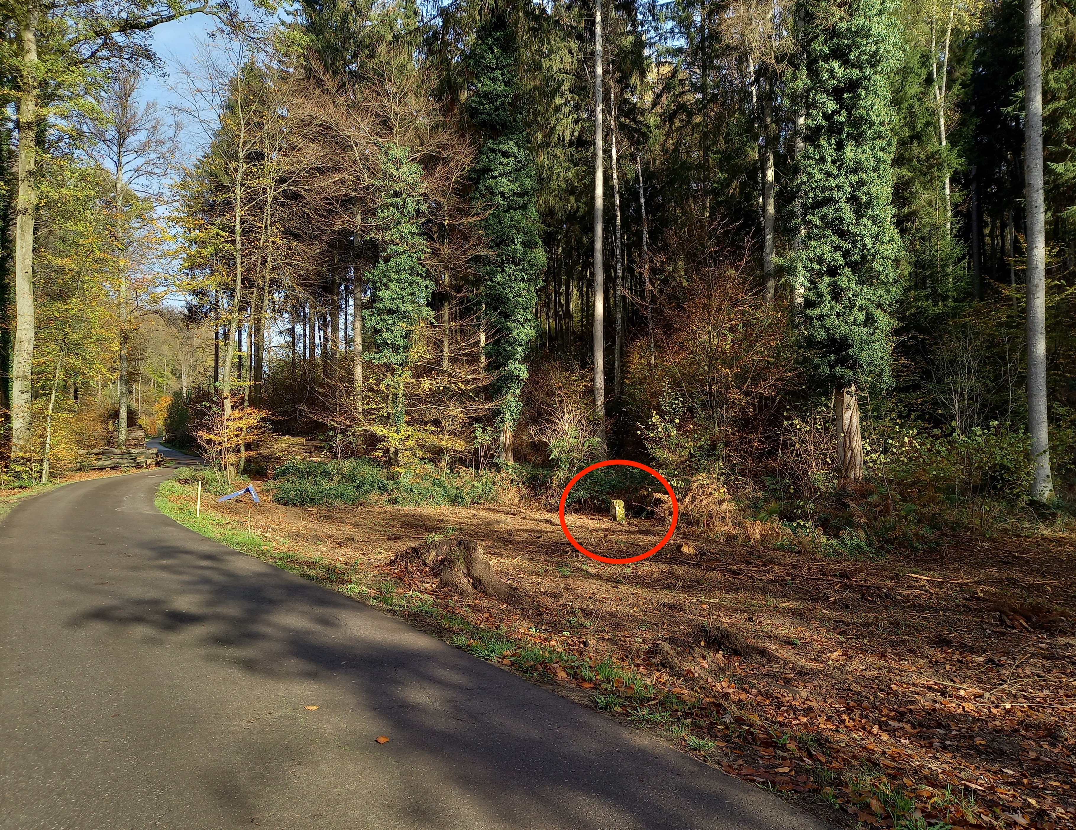
| Markers in the 1772 LL map |
Number of the marker.
Position estimations from GNSS receiver or from map deductions.
Receiver estimations with
GPStest;
they should have an accuracy below 2 meters.
Map deductions come from
Overpass,
direct OSM analysis,
and
overlay.
Position distance between two markers in meters calculated with the
Haversine formula,
program.
Estimation type, from:
receiver, or map deductions.
Map distance between to markers in meters calculated from the toises on the
Bambësch 1772 map.
Toises on the
Bambësch 1772 map
(1 toise = 1.949 meters).
|
| N |
Position
P |
E
M |
T |
Marker |
Surroundings |
Comments |
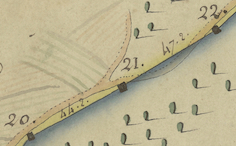
| 1
| 49.62425
6.10095
| m
|
| Missing
|
| 35-41, rue de Reckenthal
|
|
| 153.03
| 141
| 72.20
| distance difference= 12.03
|
| 2
| 49.62409
6.09884
| m
|
| Missing
|
| 53-59, rue de Reckenthal. Before 1874, some markers between 2 and 11 has been removed and replaced [Modert].
|
|
| 105.95
| 112
| 57.30
| distance difference= -6.05
|
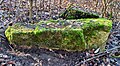
| 3
| 49.62425
6.09739
| m
|
| Missing
|
| 63-69, rue de Reckenthal
|
|
| 137.45
| 136
| 70.00
| distance difference= 1.45
|
| 4
| 49.62442
6.09550
| m
|
| Missing
|
| 83-93, rue de Reckenthal
|
|
| 139.45
| 139
| 71.40
| distance difference= 0.45
|
| 5
| 49.62502
6.09380
| m
|
| Missing
|
| Reckenthal, VDL workshop
|
|
| 228.05
| 199
| 102.20
| distance difference= 29.05
|
| 6
| 49.62627
6.09129
| m
|
| Missing
|
| Reckenthal, VDL workshop
|
|
| 190.07
| 183
| 94.00
| distance difference= 7.07
|
| 7
| 49.62740
6.08931
| m
|
| Missing
|
| Reckenthal
|
|
| 206.31
| 209
| 107.00
| distance difference= -2.69
|
| 8
| 49.62827
6.08678
| m
|
| Missing
|
| Reckenthal, Centre équestre
|
|
| 129.81
| 141
| 72.20
| distance difference= -11.19
|
| 9
| 49.62849
6.08501
| m
|
| Missing
|
| Reckenthal, Centre équestre
|
|
| 171.02
| 191
| 98.00
| distance difference= -19.98
|
| ↑ 10
| 49.62871
6.08266
| m
|
| Missing
|
| Reckenthal, shooting range
|
|
| 230.50
| 220
| 113.00
| distance difference= 10.50
|
| ↑ 11
| 49.62868
6.07946
| m
|
| Missing
|
| Eierbierg, shooting range
|
|
| 174.45
| 178
| 91.30
| distance difference= -3.55
|
| ↑ 12
| 49.62830
6.07711
| m
|
| Missing
|
| Eierbierg, water lakes
|
|
| 136.37
| 135
| 69.30
| distance difference= 1.37
|
| ↑ 13
| 49.62794
6.07530
| m
|
| Missing
| 
| Eierbierg, near the A6 motorway.
|
|
| 184.00
| 197
| 101.00
| distance difference= -13.00
|
| ↑ 14
| 49.62741
6.07288
| m
|
| Missing
| 
| 
Overview of the locations for markers 14 to 16.
Location: Centre regional pour déchets inerte (a landfill) in the Schleidberg. This small part is cut-off from the Bambësch by the A6 motorway.
|
|
| 187.01
| 175
| 90.00
| distance difference= 12.01
|
| ↑ 15
| 49.62857
6.07100
| m
|
| Missing
| 
| Location: Centre regional pour déchets inerte (a landfill) in the Schleidberg. This small part is cut-off from the Bambësch by the A6 motorway.
|
|
| 39.67
| 51
| 26.20
| distance difference= -11.33
|
| ↑ 16
| 49.62884
6.07064
| m
|
| Missing
| 
| Location: Centre regional pour déchets inerte (a landfill) in the Schleidberg. This small part is cut-off from the Bambësch by the A6 motorway.
|
|
| 101.58
| 80
| 41.30
| distance difference= 21.58
|
| ↑ 17
| 49.62971
6.07021
| r
|
| Missing
| 
| Near the A6 motorway. It was already missing in 1937 [Modert].
|
|
| 124.28
| 143
| 73.20
| distance difference= -18.72
|
| ↑ 18
| 49.63074
6.06954
| r
|
| 
| 
|
|
|
| 167.07
| 170
| 87.00
| distance difference= -2.93
|
| ↑ 19
| 49.63222
6.06914
| r
|
| 
| 
|
|
|
| 182.58
| 174
| 89.20
| distance difference= 8.58
|
| ↑ 20
| 49.63380
6.06983
| r
|
| 
| 
|
|
|
| 98.72
| 86
| 44.20
| distance difference= 12.72
|
| ↑ 21
| 49.63444
6.07078
| r
|
| Missing

| 
| Map Warper estimated coordinates: 49.6343759,6.0705632
Location according to the 1772 LL map
|
|
| 73.62
| 92
| 47.20
| distance difference= -18.38
|
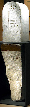
| ↑ 22
| 49.63494
6.07145
| r
|
| 
| 
| 
J. Schaack, MNHA. The drawing and the picture are nearly identical. The drawing is used in the Histoire du droit dans le Grand Duché de Luxembourg, N. Majerus, page 444.
|
|
| 87.07
| 82
| 42.00
| distance difference= 5.07
|
| ↑ 23
| 49.63565
6.07196
| r
|
| 
| 
|
|
|
| 70.01
| 71
| 36.30
| distance difference= -0.99
|
| ↑ 24
| 49.6361
6.07264
| r
|
| 
| 
|
|
|
| 109.57
| 105
| 54.00
| distance difference= 4.57
|
| ↑ 25
| 49.63693
6.07346
| r
|
| 
| 
|
|
|
| 103.07
| 104
| 53.30
| distance difference= -0.93
|
| ↑ 26
| 49.63782
6.07386
| r
|
| 
| 
| 
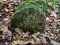
There is a survey marker on top.
|
|
| 83.31
| 80
| 41.00
| distance difference= 3.31
|
| ↑ 27
| 49.63854
6.07418
| r
|
| 
| 
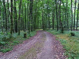
| Marker 27-30 away from the path. Troublesome access.
Light earthwork between 27 and 30
|
|
| 72.73
| 72
| 37.00
| distance difference= 0.73
|
| ↑ 28
| 49.63908
6.07475
| r
|
| 
| 
| Marker 27-30 away from the path.
Light earthwork between 27 and 30
|
|
| 75.26
| 82
| 42.00
| distance difference= -6.74
|
| ↑ 29
| 49.63962
6.07538
| r
|
| 
| 
| Marker 27-30 away from the path. Troublesome access: lots of vegetation.
Light earthwork between 27 and 30
|
|
| 71.75
| 68
| 35.00
| distance difference= 3.75
|
| ↑ 30
| 49.64014
6.07597
| r
|
| 
| 
| Marker 27-30 away from the path. Troublesome access: lots of vegetation.
Light earthwork between 27 and 30
|
|
| 94.14
| 96
| 49.20
| distance difference= -1.86
|
| ↑ 31
| 49.64093
6.07644
| r
|
| 
| 
|
|
|
| 84.37
| 79
| 40.30
| distance difference= 5.37
|
| ↑ 32
| 49.64160
6.07699
| r
|
| 
| 
|
|
|
| 78.20
| 82
| 42.00
| distance difference= -3.80
|
| ↑ 33
| 49.64229
6.07720
| r
|
| 
| 
| The inscription faces the wrong direction. Hypothesis
In plain language: the marker was moved to the left of the path and turnaround. More details: the person that moved this marker was not aware that inscriptions have to face the Bambësch. The error came because: other markers in this section are placed to the west of the path, so inscriptions face the Bambësch to the east and they can be read from the path; this marker is to the east of the path, so to make inscription readable from the path, it has to face west away from the Bambësch.
|
|
| 88.20
| 84
| 43.30
| distance difference= 4.20
|
| ↑ 34
| 49.64308
6.07731
| r
|
| 
| 
|
|
|
| 98.02
| 101
| 52.00
| distance difference= -2.98
|
| ↑ 35
| 49.64396
6.07723
| r
|
| 
| 
| Copy of a few centimeters thick at Devashaff. |
|
| 83.19
| 67
| 34.30
| distance difference= 16.19
|
| ↑ 36
| 49.64470
6.07740
| r
|
| 
| 
|
|
|
| 49.56
| 70
| 36.00
| distance difference= -20.44
|
| ↑ 37
| 49.64514
6.07751
| r
|
| 
| 
| Top section broken from the bottom buried section.
|
|
| 59.39
| 58
| 30.00
| distance difference= 1.39
|
| ↑ 38
| 49.64564
6.07780
| r
|
| 
| 
|
|
|
| 66.74
| 62
| 32.00
| distance difference= 4.74
|
| ↑ 39
| 49.64623
6.07797
| r
|
| 
| 
| Troublesome access: about 40 meters from the path with lots of vegetation.
|
|
| 69.92
| 77
| 39.30
| distance difference= -7.08
|
| ↑ 40
| 49.6468
6.07838
| r
|
| 
| 
| The Dräi Häre Maarken. Only the marker with the number 40 is part of the Limes Luxemburgensis.
|
|
| 64.54
| 62
| 32.00
| distance difference= 2.54
|
| ↑ 41
| 49.64666
6.07925
| r
|
| 
| 
| Markers 41-44 are about 20 to 30 meters parallel to the path.
|
|
| 49.74
| 43
| 22.00
| distance difference= 6.74
|
| ↑ 42
| 49.64645
6.07986
| r
|
| 
| 
| Markers 41-44 are about 20 to 30 meters parallel to the path.
|
|
| 74.95
| 88
| 45.00
| distance difference= -13.05
|
| ↑ 43
| 49.64642
6.08090
| r
|
| 
| 
| Markers 41-44 are about 20 to 30 meters parallel to the path.
|
|
| 95.69
| 94
| 48.00
| distance difference= 1.69
|
| ↑ 44
| 49.64652
6.08222
| r
|
| 
| 
| Markers 41-44 are about 20 to 30 meters parallel to the path.
|
|
| 82.12
| 76
| 39.00
| distance difference= 6.12
|
| ↑ 45
| 49.64642
6.08335
| r
|
| 
| 
| Near the path.
|
|
| 68.62
| 76
| 39.00
| distance difference= -7.38
|
| ↑ 46
| 49.64637
6.08430
| r
|
| 
| 
|
|
|
| 85.83
| 82
| 42.30
| distance difference= 3.83
|
| ↑ 47
| 49.64626
6.08548
| r
|
| 
| 
|
|
|
| 81.22
| 84
| 43.00
| distance difference= -2.78
|
| ↑ 48
| 49.64613
6.08659
| r
|
| 
| 
| Markers 48-51 are on earthwork about 20 meters parallel to the path.
|
|
| 87.15
| 88
| 45.00
| distance difference= -0.85
|
| ↑ 49
| 49.64615
6.08780
| r
|
| 
| 
| Markers 48-51 are on earthwork about 20 meters parallel to the path.
|
|
| 89.84
| 90
| 46.00
| distance difference= -0.16
|
| ↑ 50
| 49.64606
6.08904
| r
|
| 
| 
| Markers 48-51 are on earthwork about 20 meters parallel to the path.
|
|
| 88.59
| 84
| 43.00
| distance difference= 4.59
|
| ↑ 51
| 49.64604
6.09027
| r
|
| 
| 
| Markers 48-51 are on earthwork about 20 meters parallel to the path.
|
|
| 67.76
| 86
| 44.30
| distance difference= -18.24
|
| ↑ 52
| 49.64601
6.09121
| r
|
| Missing
| 
|
|
|
| 101.10
| 82
| 42.00
| distance difference= 19.10
|
| ↑ 53
| 49.64594
6.09261
| r
|
| 
| 
| Partial unidentified marker. Located crossing the path near marker 53. The top with the number is missing. It is horizontally on the ground, not vertically stuck into the ground. The part that it is usually buried is visible to the right: about 1 meter in length. It might be the original marker 53 as the current looks new.
49.64580,6.09251
|
|
| 91.47
| 90
| 46.20
| distance difference= 1.47
|
| ↑ 54
| 49.64596
6.09388
| r
|
| 
| 
|
|
|
| 91.99
| 86
| 44.30
| distance difference= 5.99
|
| ↑ 55
| 49.64605
6.09515
| r
|
| 
| 
|
|
|
| 89.45
| 96
| 49.00
| distance difference= -6.55
|
| ↑ 56
| 49.64610
6.09639
| m
|
| 
| 
| Not visible from the path. About 20 meters away.
|
|
| 99.04
| 80
| 41.30
| distance difference= 19.04
|
| ↑ 57
| 49.646187
6.097759
| m
|
| 
| 
| No visible inscription.
|
|
| 90.12
| 109
| 56.00
| distance difference= -18.88
|
| ↑ 58
| 49.64616
6.09901
| r
|
| 
| 
| Marker visible from Google Street View.
Marker displaced about 15 meters in 1997; the original location indicated the by a plaque on the middle of the street, coordinates: 49.64618,6.09924.

Green: plaque indicating the original location. Red: current location of the marker.

Near La Croix des Bourgeois (Biergerkräiz) which is drawn in the 1772 map.
 . .
Cross visible from Google Street View.
|
|
| 82.20
| 67
| 34.30
| distance difference= 15.20
|
| ↑ 59
| 49.64620
6.10015
| r
|
| 
| 
| Additional inscription: "CC 1997". The marker looks new, so it was probably placed in 1997.Visible from Google Street View.
|
|
| 76.00
| 74
| 38.00
| distance difference= 2.00
|
| ↑ 60
| 49.64627
6.10120
| r
|
| 
| 
| Additional inscription: "CC 1997". The marker looks new, so it was probably placed in 1997.Visible from Google Street View.
|
|
| 104.69
| 92
| 47.00
| distance difference= 12.69
|
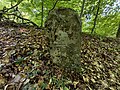
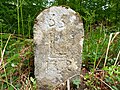
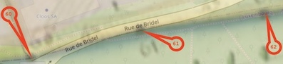
| ↑ 61
| 49.64650
6.10261
| m
|
| Missing
| 
| 
|
|
| 76.77
| 92
| 47.00
| distance difference= -15.23
|
| ↑ 62
| 49.64662
6.10366
| r
|
| 
| 
|
|
|
| 92.41
| 96
| 49.00
| distance difference= -3.59
|
| ↑ 63
| 49.64674
6.10493
| m
|
| 
| 
|
|
|
| 71.10
| 69
| 35.30
| distance difference= 2.10
|
| ↑ 64
| 49.64689
6.10589
| m
|
| 
| 
|
|
|
| 58.09
| 63
| 32.20
| distance difference= -4.91
|
| ↑ 65
| 49.64730
6.10639
| m
|
| 
| 
|
|
|
| 51.41
| 53
| 27.00
| distance difference= -1.59
|
| ↑ 66
| 49.64771
6.10672
| m
|
| Missing
| 
| Probably under the road
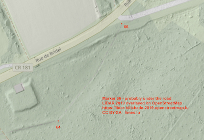
|
|
| 86.37
| 97
| 50.00
| distance difference= -10.63
|
| ↑ 67
| 49.64802
6.10782
| r
|
| 
| 
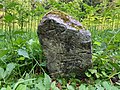
| Most of the inscription is gone; the number "7" can be seen.
|
|
| 86.72
| 82
| 42.20
| distance difference= 4.72
|
| ↑ 68
| 49.64823
6.10898
| m
|
| Missing
| 
| Coordinate should be a good approximation.
The distance between markers 67-69 according to the:
- map=148m
- coordinates=155.99m.
Hence, marker 69 might have been moved at least 7.99m to the East. Map Warper estimated coordinates: 49.6481636,6.1088061
|
|
| 70.15
| 66
| 34.00
| distance difference= 4.15
|
| ↑ 69
| 49.64837
6.10993
| r
|
| 
| 
| Marker 69 might have been moved at least 7.99m to the East.
The number looks like a 90.
|
|
| 62.35
| 66
| 34.10
| distance difference= -3.65
|
| ↑ 70
| 49.64853
6.11076
| r
|
| 
| 
| This marker was displaced a few meters as it on the road. Missing in 1937 [Modert].
|
|
| 91.95
| 88
| 45.00
| distance difference= 3.95
|
| ↑ 71
| 49.64783
6.11144
| r
|
| 
| 
| Before
|
|
| 55.25
| 55
| 28.00
| distance difference= 0.25
|
| ↑ 72
| 49.64737
6.11173
| r
|
| 
| 
| Before
|
|
| 44.42
| 41
| 21.00
| distance difference= 3.42
|
| ↑ 73
| 49.64709
6.11217
| r
|
| 
| 
|
|
|
| 94.22
| 92
| 47.00
| distance difference= 2.22
|
| ↑ 74
| 49.64637
6.11286
| r
|
| 
| 
|
|
|
| 72.87
| 72
| 36.90
| distance difference= 0.87
|
| ↑ 75
| 49.64576
6.11323
| r
|
| 
| 
|
|
|
| 86.52
| 84
| 43.00
| distance difference= 2.52
|
| ↑ 76
| 49.64501
6.11355
| r
|
| 
| 
|
|
|
| 72.33
| 70
| 36.00
| distance difference= 2.33
|
| ↑ 77
| 49.64436
6.11359
| r
|
| 
| 
|
|
|
| 78.11
| 69
| 35.30
| distance difference= 9.11
|
| ↑ 78
| 49.64366
6.11368
| r
|
| 
| 
|
|
|
| 62.27
| 74
| 38.00
| distance difference= -11.73
|
| ↑ 79
| 49.64310
6.11368
| r
|
| 
| 
|
|
|
| 131.58
| 133
| 68.00
| distance difference= -1.42
|
| ↑ 80
| 49.64196
6.11417
| m
|
| 
| 
| No visible inscription.
|
|
| 60.68
| 62
| 32.00
| distance difference= -1.32
|
| ↑ 81
| 49.64145
6.11447
| r
|
| 
| 
| Markers 81-84 are about 10 to 20 meters parallel to the path.
|
|
| 54.98
| 51
| 26.20
| distance difference= 3.98
|
| ↑ 82
| 49.64099
6.11475
| r
|
| 
| 
| Markers 81-84 are about 10 to 20 meters parallel to the path.
|
|
| 84.19
| 77
| 39.30
| distance difference= 7.19
|
| ↑ 83
| 49.64026
6.11506
| r
|
| 
| 
| Markers 81-84 are about 10 to 20 meters parallel to the path.
|
|
| 82.75
| 82
| 42.00
| distance difference= 0.75
|
| ↑ 84
| 49.63956
6.11545
| r
|
| 
| 
| Markers 81-84 are about 10 to 20 meters parallel to the path.
|
|
| 66.30
| 78
| 40.20
| distance difference= -11.70
|
| ↑ 85
| 49.63899
6.11572
| m
|
| Missing
|
| Location: locked yard. It might be buried.
|
|
| 67.27
| 63
| 32.30
| distance difference= 4.27
|
| ↑ 86
| 49.63839
6.11584
| r
|
| 
| 
| Located inside a ditch.
|
|
| 74.45
| 66
| 34.00
| distance difference= 8.45
|
| ↑ 87
| 49.63776
6.11619
| r
|
| 
| 
|
|
|
| 81.89
| 92
| 47.40
| distance difference= -10.11
|
| ↑ 88
| 49.63703
6.11604
| r
|
| 
| 
| 
Additional inscription: "CC 1997".
The original marker is in the store of the History Museum of the City of Luxembourg. © of the picture, same museum.
|
|
| 83.30
| 86
| 44.00
| distance difference= -2.70
|
| ↑ 89
| 49.63630
6.11578
| m
|
| Missing
|
|
|
|
| 100.17
| 99
| 51.00
| distance difference= 1.17
|
| ↑ 90
| 49.63540
6.11572
| m
|
| Missing
|
| 99-103, rue des Sept-Arpents
If in the Bëschspillschoul, it might be visible even under the building: "wood structure placed on metal piles" | structure bois posée sur des pieux métalliques, page 35.
|
|
| 207.44
| 207
| 106.00
| distance difference= 0.44
|
| ↑ 91
| 49.63363
6.11663
| m
|
| Missing
|
| 71-77, rue des Sept-Arpents
|
|
| 150.77
| 142
| 73.00
| distance difference= 8.77
|
| ↑ 92
| 49.63232
6.11717
| m
|
| Missing
|
| 48-52, rue Jean-Pierre Huberty
|
|
| 143.07
| 142
| 73.00
| distance difference= 1.07
|
| ↑ 93
| 49.63108
6.1177
| m
|
| Missing
|
| 24-30, rue Jean-Pierre Huberty
|
|
| 72.45
| 70
| 36.00
| distance difference= 2.45
|
| ↑ 94
| 49.63043
6.11777
| m
|
| Missing
|
| 11-17, rue Jean-Pierre Huberty
|


